contact
contact
ForYou Club
10 °C
Webcam
6 / 13 Open facilites
Current info
Ramsau am Dachstein

Via Ferrata Amon

Ascent of the Amon Klettersteig
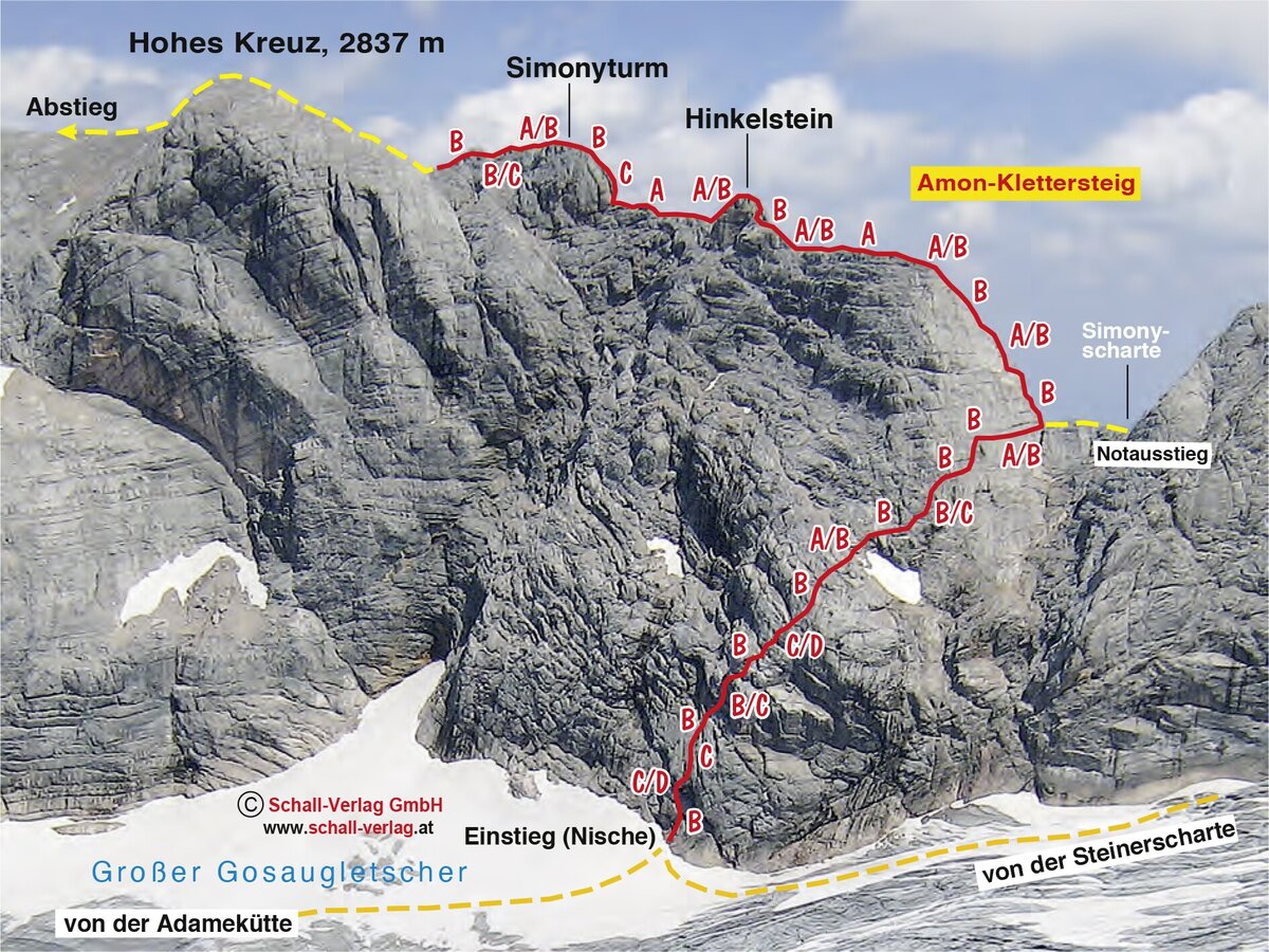
Topography Amon-Klettersteig Hohes Kreuz
Mountaineers on the Amon Klettersteig

Tour description

The Amon Klettersteig provides a connection between the Adamek- and Simonyhütte. A very rewarding, though high-alpine via ferrata that should not be underestimated, with approach/descent across the glacier. Aside from alpine experience and good physical condition, glacier equipment is also essential.

Times:

  • Via Ferrata - 2:30 h
  • Time to Base - 2:00 h
  • Time from Top - 1:30 h
  • Total - 6:00 h

The tour

C/D
Tour characteristics
Exposition:
Distance: 1500 m Climbing time: 2 h 30 min
Information
Elevation at the starting point: 2687 m
Hiking time to the starting point: 2 h
Elevation at the entrance: 2520 m
Elevation gain on the via ferrata: 360 m
Elevation at the exit: 2835 m
Walking time (descent): 1 h 30 min
highest point: 2837 m
Best season
Jan
Feb
Mar
Apr
May
Jun
Jul
Aug
Sep
Oct
Nov
Dec

Map, elevation profile & further information

From the Dachstein Glacier cable car mountain station, the groomed trail leads towards the Seethalerhütte. At the bend towards the Seethalerhütte, continue straight ahead. Pass the Steinerscharte to the Simonyscharte. From there, the rope safety equipment of the upper section of the Amon via ferrata (C) begins. The entire Amon via ferrata can be reached via the Steinerscharte to the Gosau Glacier (constant danger of crevasses!), descending to directly below the west face. The access point (C/D) is located there.
Descend the trail back to the Simonyscharte, and from there return to the Dachstein Glacier cable car mountain station. A descent via the Niederes Kreuz to the Hallstatt Glacier is also possible – high-alpine experience is essential here.

Arriving from the west: From the west you can take the Munich-Salzburg motorway, continuing on the Tauern motorway (A 10) until the Ennstal junction. From here take the Ennstal A-road (the B 320) for around 30 km into the Schladming-Dachstein region, then take the Ramsau am Dachstein turn-off.

Arriving from the north: From the south-east take the Pyhrnautobahn motorway (A 9) to the Liezen junction and then the Ennstal A-road (B 320) into the Schladming-Dachstein region. Then take the Ramsau am Dachstein turn-off.


Parking lot at the bottom station of the Dachstein glacier

From Schladming Rathausplatz (town center) or the train station, take bus line 960 of the Ramsau public transport company to the final stop at the valley station of the Dachstein Glacier Cable Car.

From there with the Dachstein cable car to the starting point Bus timetable: www.verbundlinie.at

Wheather predicition

today
23.10.2026
Mountain -3 °C
Valley 11 °C
Snow
Mountain
8 cm
Valley
0 cm
Wind speed
West
20 km / h
Precipitation
Probability
80 %
Amount
7.5 l/m²
Sun
Sun hours
6.6 h
Sunrise
07:36 o clock
Sunset
18:03 o clock

The day starts sunny, but will be partly cloudy in the afternoon.

tomorrow
24.10.2026
Mountain -7 °C
Valley 4 °C
Snow
Mountain
2 cm
Valley
0 cm
Wind speed
Nordwest
10 km / h
Precipitation
Probability
85 %
Amount
1.6 l/m²
Sun
Sun hours
1.5 h
Sunrise
07:37 o clock
Sunset
18:02 o clock

Snowfall will continue into the afternoon, then the clouds will break up.

day after tomorrow
25.10.2026
Mountain -2 °C
Valley 8 °C
Snow
Mountain
5 cm
Valley
0 cm
Wind speed
West
15 km / h
Precipitation
Probability
70 %
Amount
5.7 l/m²
Sun
Sun hours
0.3 h
Sunrise
06:38 o clock
Sunset
17:00 o clock

Sunny in the early morning, then increasingly cloudy and finally some snowflakes.

Tours nearby